Categories
Events and People Snapshots of History

Schuykill River Floods, March 1902


Purchase Photo View Nearby Photos
Baltimore and Ohio Railroad Station During Flood – Flooded Train Shed.

With the recent record levels of rainfall in Philadelphia, images such as these two photos have unfortunately become a familiar sight in our area. Though most Philadelphians do not remember another time when there seemed to be so much water everywhere, the city is actually no stranger to disastrous flooding.

The combination of a particular harsh winter that led to above-average amounts of melting snow plus the occurrence of a severe rainstorm on the night of February 28, 1902 led to so much water flowing into the Schuylkill River that it “broadened to twice its normal width.” As the sun rose on the morning of March 1, people were able to see just how bad the overnight devastation was. The sight of the swollen river full of debris set against a perfect blue-sky morning was one of such “ruinous grandeur” that it brought “thousands of spectators to bridges and points of vantage.”


Purchase Photo View Nearby Photos
Baltimore and Ohio Railroad Station During Flood – Flooded Waiting Room.

The two photos here show the Baltimore & Ohio Railroad Station located on the east bank of the Schuylkill at 24th and Chestnut Streets. Designed by Frank Furness and opened in 1888, the station was constructed so that the main entrance was level with the Chestnut Street Bridge with passenger waiting areas and tracks 30 feet below. While this design allowed for better flow of passengers by providing for both upper and lower waiting areas, it also meant that the lower areas were particularly vulnerable to flooding. On the morning of March 1, it was reported that the lower levels of the station had taken in five feet of water. By the afternoon, the level was reported to have lowered to a foot and a half, which would appear to be when the photos were taken. B&O had suspended service the night before as water slowly crept into the station, but by the next day the flooding had wreaked havoc on other rail lines as well. Both the Pennsylvania and Philadelphia & Reading Railroads also suspended service.


It took many months and millions of dollars for Philadelphia to recover from the flood. The Baltimore & Ohio Railroad reopened the 24th Street Station and used it continuously until April 1956 when B&O suspended all passenger service north of Baltimore. The station was demolished in 1963 and the site is now home to a luxury high-rise apartment building

Sources:

“Schuylkill is a Raging Torrent.” The Philadelphia Inquirer, March 1, 1902.

“Swollen Schuylkill Bursts Its Bounds, Throttling Traffic, Damaging Property.” The Philadelphia Inquirer, March 2, 1902.

Categories
Urban Planning

“The Boulevard”


Purchase Photo View Nearby Photos

Roosevelt Boulevard, officially named the Theodore Roosevelt Memorial Boulevard, is one of Philadelphia’s most important traffic arteries. It carries millions of drivers every day and is arguably the backbone of Northeast Philadelphia. Roosevelt Boulevard has become such a part of Philadelphia that when one speaks of “the Boulevard” anyone who’s lived in Philadelphia for any significant length of time, whether they reside in the Northeast or not, knows immediately which road is being referenced.

The origins of the Boulevard date back to 1902 when Mayor Samuel H. Ashbridge proposed the construction of a road to connect central Philadelphia to the communities in the northeastern reaches of the city. At this time, most of the Northeast was rural farmland communities connected by a loose network of dirt roads. Ashbridge had to convince a reluctant Common Council (the predecessor of City Council) that the Boulevard was worth the cost of construction, arguing that it would open the Northeast to greater expansion and development which would be beneficial to the whole city.


Purchase Photo View Nearby Photos

Purchase Photo View Nearby Photos

When first built, the boulevard ran from Broad Street into the city’s Torresdale neighborhood. In the initial planning stages, the boulevard was to be called the Torresdale Boulevard. At its completion, however, it was renamed the Northeast Boulevard. It wasn’t until it was expanded to reach Pennypack Creek in 1918 that the boulevard was given its present moniker in honor of former president Theodore Roosevelt. In 1926, the Boulevard became a part of the first Federal interstate highway system, designated as US Route 1. The extension of the Boulevard continued over the next decades into the Far Northeast until it reached its current end point just across the border of Bucks County in the late 1950s.


Purchase Photo View Nearby Photos

In 1961, the Boulevard grew again when it was connected to Interstate 76 via an extension called the Roosevelt Expressway. The Roosevelt Expressway runs from its connection with I-76 at the Schuylkill River through North Philadelphia to connect with Roosevelt Boulevard near Hunting Park Avenue. While this provided an important link to I-76, it only increased traffic on the already congested Boulevard. Adding lanes did not solve the problem, and many other solutions have been proposed over the decades. One idea was to extend the Broad Street Subway line out to the Northeast. This idea came so close to fruition that Sears built a subway station underneath their famed Merchandise Center located along the Boulevard. Other people suggested building another road entirely. Called the Northeast Expressway, this new road would roughly follow the path of the Boulevard. Needless to say, the Northeast Expressway was never built, and Roosevelt Boulevard remains one of the most congested roads in the country.

Mayor Ashbridge was right; with each extension of the Boulevard, development of the surrounding area soon followed. Today, it would be difficult to imagine the Northeast without Roosevelt Boulevard. Because it played such a vital role in the growth and development of the neighborhoods in the Northeast, one has to wonder how much of “the Northeast” would exist as an urban area had the Boulevard not been built.

Sources:

“Roosevelt Expressway Historic Overview” – http://www.phillyroads.com/roads/roosevelt/

“US 1; John H. Ware III Memorial Highway; Roosevelt Expressway; Roosevelt Boulevard; Martin Luther King Jr. Expressway” – http://www.pahighways.com/us/US1.html

Categories
Snapshots of History

Food Will Win the War


Purchase Photo View Nearby Photos
Supply trucks gathered at City Hall.

World War I is often referred to as the first “modern war.” Weapons such as airplanes, tanks, machine guns, and chemicals were used for the first time with deadly consequences. However, one of the oldest weapons in human history was also employed during the War – food. Starving a city or fortress to surrender is a tactic that dates back to ancient times. History has shown that in matters of war the victor is not always the one with the largest army or most advanced weapons. Often, it is the one who can continue to feed its army and citizens. World War I was no different. As Europe sent its most able-bodied young men into the trenches, food production began to decrease. The United States, being a neutral country at this point and possessing a surplus of food, became critical in supplying food to its (unofficial at the time) allies in Europe.

By the time America entered the war in April 1917, however, European demand had depleted food reserves and driven up prices. Since farmers could not increase production until the following year’s harvest, it became clear that America would have to conserve food if it was to continue to feed itself, its growing and mobilizing army, and its allies. Federal legislation was introduced to control food supplies, but a frustrated President Woodrow Wilson felt that something needed to be done faster. Wilson urged the passing of the Lever Food and Fuel Control Act in 1917 as an emergency wartime measure. With its passing, the Lever Act created the United States Food Administration to control the growing supply problem. President Wilson appointed as head of the administration a man who would later become president himself – Herbert Hoover. Hoover had previously been in London organizing, sometimes surreptitiously, relief efforts for the people of Europe, especially in Belgium.


Purchase Photo View Nearby Photos
City Hall illuminated at night with Hoover’s famous slogan.


Hoover believed that “food will win the war” but did not want to embark upon a rigid and mandatory rationing program. He believed that in “the spirit of self-denial and self-sacrifice” Americans would voluntarily modify their eating habits. A national campaign, mostly aimed at women, was introduced to encourage conservation of food and the elimination of waste. Special recipes and cookbooks were disseminated. Victory Bread, bread made with a flour substitute called (appropriately) Victory Flour, became a staple in many homes. Nation-wide weekly events such as “Meatless Mondays” and “Wheatless Wednesdays” were promoted. Children were told to east less sweets in order to “save sugar for a soldier.” Supply-truck motorcades were organized to bring food directly from rural areas into major cities and ports, with Philadelphia being a major hub of this kind of activity. In public spaces throughout the country, cities prominently displayed signs and posters bearing Hoover’s famous statement “Food Will Win the War.” Americans began to informally refer to their modified eating habits as “Hooverizing.”


During the first year of the U.S. Food Administration’s existence, Americans reduced their food consumption by 15 percent. That number may not sound like much, but it doubtless fed many a starving ally or American doughboys across the Atlantic. After the war, Hoover continued the humanitarian efforts of the U.S. Food Administration, which had been reorganized and renamed the American Relief Organization. Hoover expanded relief to include not just America’s allies but also it’s recently defeated former enemies, declaring “Twenty million people are starving. Whatever their politics, they shall be fed!”

“Hooverizing” recipes are widely available. For the recipes and to see the finished products, please visit http://foodwillwinthewar.blogspot.com/.

Sources:

“Wilson Orders Hoover to Start.” The New York Times, June 16, 1917. Accessed June 16, 2011. http://query.nytimes.com/mem/archivefree/pdf?res=FA0711FD385E11738DDDAE0994DE405B878DF1D3.

Goudiss, Alberta Moorhouse and Charles Houston Goudiss. Foreward to Foods That Will Win the War: And How To Cook Them. New York: The Forecast Publishing Company, 1918. Accessed June 16, 2011. http://books.google.com/books?id=k9sqAAAAYAAJ

Hammond, R.J. “Review of The History of the United States Food Administration, 1917-1919 by William C. Mullendore.” The English Historical Review, vol. 58, no. 230 (April 1943). Accessed June 16, 2011.

“Food Will Win the War” is part of “Snapshots of History,” a new series of blog entries that will provide background info on select images from the PhillyHistory.org database.

Categories
Snapshots of History

Kill the Rats!


Purchase Photo View Nearby Photos

When we hear “bubonic plague” most people tend to think of the “Black Death” that swept across 14th century Europe. Transmitted to humans by bites from infected rat-fleas, the pandemic infamously killed up to a third of the entire population of Europe. What is mostly unknown is that bubonic plague also had deleterious effects on the populations of Asia, South America and North America. Cases of bubonic plague have been reported in nearly every country in the world. And while we also tend to think of bubonic plague as relegated to the history books, stunningly, cases are still being reported into the 21st century.

The United States remained plague-free until 1900 when an outbreak occurred in San Francisco. Though this outbreak was nowhere near the proportions that had affected Europe and Asia (“only” 121 people died), it was enough to thoroughly scare some other states into ending all trade with the entire state of California, fearing that the plague would literally be imported into their populations as well. Since rat infestations were mostly a problem of urban centers, many American cities began to put in place practices to stave off an outbreak of plague.

Philadelphia was no exception. Philadelphians were urged to “rat-proof” their homes and businesses and to turn over any trapped rats to the city for disposal. On September 4, 1914, the Philadelphia Bureau of Health erected a rat receiving station at the Race Street Pier and offered a bounty: two cents for each dead rat and five cents for live ones. By January 1, 1915, the Bureau reported that 5,238 rats had been turned in to the station. The Bureau of Health was also greatly expanded during this time including the hiring of a team of special agents, the “rat patrol”, who inspected all incoming ships and set and monitored traps all along the waterfront.

The measures apparently worked as Philadelphia did not experience a plague outbreak. Fears of bubonic plague would be overshadowed in a few years as Philadelphians, and indeed all Americans, would have to contend with a far more deadly epidemic – the Great Influenza.

http://www.phillyhistory.org/PhotoArchive/Detail.aspx?AssetId=7769

Source:

Zueblin, Charles. American Municipal Progress. New York: The MacMillan Company, 1916, p. 129.

“Kill the Rats!” is the first article in “Snapshots of History,” a new series of blog entries that will provide background info on select images from the PhillyHistory.org database.

Categories
Urban Planning

The Girard Piers


Purchase Photo

Philadelphia’s Delaware River waterfront has played a significant role in the city’s development ever since William Penn himself stepped foot on the area we now call, rather appropriately, Penn’s Landing. Penn’s oft-mentioned plan for Philadelphia as a “greene country towne” included a tree-line waterfront that would serve as a serene promenade for Philadelphians to come and relax. However, the waterfront quickly become the economic and commercial heart of the young city, with the Delaware River serving as a major highway for the importing and exporting of goods from the European continent. Penn’s idea of serenity quickly gave way to the hustle and bustle of a rapidly expanding city. As the city grew, shops, warehouses, and factories continued to cluster along the waterfront, and with the advent of the railroad in the mid-19th century, the area become further congested with tracks leading from the docks, piers, and warehouses into the interior of the country.

For the first centuries of the nation’s life, Philadelphia was considered by many to be its most major port. However, by the early-20th century, Philadelphia’s port infrastructure was showing its age, and Philadelphia had clearly been surpassed in importance by ports in cities like New York City, Boston, and Baltimore. In 1907, the City of Philadelphia created the Department of Wharves, Docks, and Ferries and tasked it with rejuvenating the waterfront area and making it once again a competitive port for international trade and commerce. This long-term plan included the dredging of the Delaware River channel from the sea to Allegheny Avenue to a depth of 35 feet to handle larger ships, the construction of the Delaware River Bridge (now called the Benjamin Franklin Bridge), and the construction of several new, municipally-owned piers to be leased out to private companies. The entire project took two decades to be fully realized and cost an extraordinary (for the time) $27,000,000.


Purchase Photo

Purchase Photo

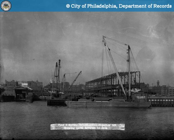
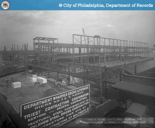
One of the last components of the project was the construction of Piers 3 and 5 North in 1922-23. These two new piers were constructed on the site of several aging wooden wharves built in the 19th century with money that had been left to the city by Stephen Girard. Therefore, the piers were officially called the “New Girard Group”, though they came to unofficially be known as just the “Girard Group” or the “Girard Piers.” These double deck piers were designed with all the latest technological advances of the time in order to increase efficiency and handle the maximum amount of cargo in one day. They extended 550 feet into the river, the maximum amount allowed by the federal government to maintain safe navigation of ships through the channel, and could therefore service more than one ship at a time. “Turn over” doors that folded upward and inward ran along the entire length of each side of the piers and allowed for the loading or unloading of cargo from a ship’s deck from any point along the pier. Each pier had about 100,000 square feet of storage space and also contained office space on both the upper and lower decks for the companies who would lease the piers. Finally, each pier had an automatic sprinkler system installed that was connected to the city’s water system.


Purchase Photo

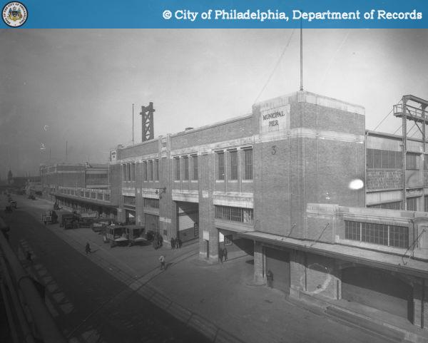
While the steel-framed sides of the piers were certainly utilitarian in their appearance, the inshore and outshore steel frames were encased in brick and limestone and were designed with utmost care by John Penn Brock Sinkler, City Architect from 1920-1924. The embellished facades belied the piers’ strictly industrial use, and at the time they stood in stark contrast to the plainness of normal pier design. The Girard Group’s blend of state-of-the art functionality with architectural expression was said to have ushered in a “new interpretation of industrial architecture.”

Despite all of their technological advancements, the Girard Group piers were rendered obsolete after World War II with the construction of newer port facilities in South Philadelphia and changes in methods of cargo handling, particularly the rise of containerization. The Delaware waterfront industry in general began to suffer in the 1950s and 1960s as companies moved to markets with cheaper labor. Demolition of many waterfront factories and warehouses in order to construct Interstate-95 in the late 1960s delivered a final crushing blow. The Girard Group, once a source of great pride for the city, sat derelict and decrepit.

As Philadelphia began to plan for the country’s bicentennial, city planners sought to finally realize William Penn’s vision of a tree-lined promenade along the waterfront. Called Penn’s Landing, the Girard Group were marked for demolition to make way for this park. However, like other large-scale city projects, only half of Penn’s Landing was finished in time for the bicentennial, thereby sparing the Girard Group. In 1983 the Girard Group were added to the National Register of Historic Places and were renovated as luxury condominiums. Renamed “The Piers at Penn’s Landing,” the luxury condo conversion struggled at first, but by the 1990s they were successfully established luxury condominiums. The turn-over doors once used for loading and unloading cargo became large picture windows, the railroad entry and loading depot on the ground floor became a parking garage, the roofs of both piers were removed creating a sun-drenched atrium for residents in the center of each pier, and a marina full of recreational boats rather than cargo ships now surrounds the piers.

This blending of the past with the present, with taking something old and repurposing it into something new, is something that seems to occur often in Philadelphia. The Girard Group/The Piers at Penn’s Landing stand as testaments to how adaptive reuse, plus a little patience, can further add to the rich historical story for which Philadelphia is known.

Resources:

Kyriakodis, Harry. “The History of Pier 3.”  http://www.pier3.net/history_of_pier_3.

“Piers 3 and 5 North (The Girard Group), 1923.” http://www.workshopoftheworld.com/center_city/pier_3.html.

“Penn’s Landing – William Penn’s “Greene Country Towne” has Finally Become a Reality Here.” http://www.ushistory.org/tour/penns-landing.htm.

Categories
Public Services

Public Education in Philadelphia: Philadelphia High School for Girls

The history of the Philadelphia High School for Girls, known by most Philadelphians as simply Girls’ High, can be traced back to 1848 when the city built what was called the Girls’ Normal School at the intersection of Chester Street and Maple Street, an intersection long since paved over and now covered by a parking lot at 8th and Arch Streets. It was a strange name for a school indeed and may cause one to wonder if there was also a Girls Abnormal School, but the name was somewhat misleading. “Normal” schools were schools that educated future teachers to work in primary and secondary education. When the Girls’ Normal School was established, it was not only the first secondary public school for women in the state of Pennsylvania but also the first municipally supported teacher’s school in the United States. Opened in February 1848, there were 149 students enrolled by June, a rather large number of students for any one school to have at the time. The continuing enrollment over the next few years meant that by 1854 the Girls’ Normal School needed a bigger building. In 1854 a new building was erected on Sergeant Street, now called Spring Street, between Ninth and Tenth Streets.

In 1859, the name of the school was changed to the more familiar sounding Girls’ High School of Philadelphia. However, this name change did not last long as the name was changed again one year later to The Girls’ High and Normal School in order to better emphasize that the school trained teachers but also offered classes in purely academic subjects.


Purchase Photo View Nearby Photos

As one of the few public educational institutions for women, enrollment continued to grow until the school once again needed a bigger building. In 1876, a new building located at 17th and Spring Garden Streets was erected. This building was designed to be a showcase of all the major comforts and conveniences of the day. The new building had forty classrooms, terraced lecture halls, and an auditorium capable of seating 1200 people, almost double the school’s student body of 640 at the time. The new building was so large that when it was completed, only Girard College and the University of Pennsylvania surpassed it in terms of land area used in Philadelphia.

In 1893, the High School and Normal School were separated into two distinct institutions with the Normal School moving to a building at 13th and Spring Garden Streets. It was also at this time that the building at 17th and Spring Garden was officially renamed the Philadelphia High School for Girls. In addition to the standard 3-4 year curricula, Girls’ High also instituted a three year curriculum that focused on business classes. This was unusual for the time as “business” was still very much a male-dominated sphere. In 1898, the school made another unusual choice when it started offering courses in Latin and science which were designed to prepare its female graduates for college and university-level education.


Purchase Photo View Nearby Photos

Purchase Photo View Nearby Photos

By the 1930s, the school had once again outgrown its facilities and in 1933 work began on a new building at the same location at 17th and Spring Garden Streets. This building was even larger than the last, but it was only twenty-five years later that the school had once again outgrown its facilities. Girls’ High moved to its current location at Broad Street and Olney Avenue in 1958, with the old building on Spring Garden Street becoming the Julia R. Masterman School. The Spring Garden Street building was also added to the National Register of Historic Places in 1986.

Today, Girls’ High remains one of Philadelphia’s preeminent educational institutions. As one of the city’s magnet schools, the school attracts academically gifted young ladies from all over the city. The school’s competitive admissions process and rigorous academic curriculum are not only meant to prepare its students for further college education (98% of Girls’ High graduates go on to college or university) but also to “equip students with the academic, social, emotional, and cultural foundations for success in an ever changing society.” This is evidenced by both the Code of Honor and the school’s motto “Vincit qui se vincit” – He (or in this case, she) conquers who conquers himself. The code and the motto were both adopted by the school in the early 20th century and remain a large influence on the school’s philosophy to this day. It is without a doubt that the Philadelphia High School for Girls will continue to play a major role in public education in Philadelphia for many, many years to come.

Sources:

Alumni Association of the Philadelphia High School for Girls.  http://www.ghsalumnae.com/index.html. (11 January 2011).

Greater Philadelphia Geohistory Network (1858-1860 Philadelphia Atlas). http://www.philageohistory.org/geohistory/. (18 January 2011).

M’Elroy, A. Philadelphia Directory1839: Containing the Names of the Inhabitants, Their Occupations, Places of Business, and Dwelling Houses; also A List of Streets, Lanes, Alleys, etc.; and The City Officers, Institutions, and Banks, and Other Useful Information. Philadelphia: Isaac Ashmead & Co., 1839.

The Philadelphia School District – Philadelphia High School for Girls. http://webgui.phila.k12.pa.us/schools/g/girlshigh/about-us. (11 January 2011).

Categories
Events and People

Touching Liberty (Literally)

The photographic archives of the Office of the City Representative document decades of visits to Philadelphia by various dignitaries, diplomats, and VIPs, both domestic and foreign. And of course, no visit to Philadelphia would be complete without a stop at one of the iconic symbols of America, the Liberty Bell. As the photos show, being a VIP afforded one special access to the bell.

In October 1963, Haile Selassie, Emperor of Ethiopia (1930-1974), made an official state visit to the United States to meet with President Kennedy to discuss important and pertinent issues such as U.S. aid to Ethiopia, the effect of Soviet-U.S. relations on Ethiopia and other African nations, and the sticky situation of U.S. arms being sold to Somalia, Ethiopia’s neighbor and sometimes opponent. Before getting down to business with Kennedy in Washington however, Selassie made a stop in Philadelphia. Flying directly from Geneva in a United States Air Force jet, Selassie and his entourage were greeted at Philadelphia International Airport by Mayor James Tate, numerous other city officials, a 21-gun salute, and a “bevy of brass” (the police and firemen’s band) which played both the American and Ethiopian national anthems. The first stop in Philadelphia was of course the Liberty Bell, which at this time was still housed in Independence Hall. This is our first instance of “touching liberty.”

  • Special to The New York Times. “Arms for Somalia Embarrassing U.S. on Eve of Selassie’s Visit: Ethiopian Ruler Is Expected to Raise Issue in Talks With Kennedy This Week.” New York Times (1923-Current file), September 29, 1963, http://www.proquest.com.libproxy.temple.edu/ (accessed August 4, 2010).
  • LOU POTTER. “Haile Selassie, Lion of Judah, Roars Into Philadelphia: Met by Mayor Tate and Bevy Of City Brass Winds Up Tour With Honorary Citizenship.” Philadelphia Tribune (1912-2001), October 1, 1963, http://www.proquest.com.libproxy.temple.edu/ (accessed August 4, 2010).
  • Special to The New York Times. “Haile Selassie Is Greeted On Arrival in Philadelphia: MUSIC NOTES.” New York Times (1923-Current file), October 1, 1963, http://www.proquest.com.libproxy.temple.edu/ (accessed August 4, 2010).

In April 1964, King Hussein of Jordan arrived in the Philadelphia for his third official state visit to the United States and his first official state visit with then President Lyndon B. Johnson. Serving as an “unofficial representative of the Arab world”, King Hussein was set to discuss continued U.S. economic aid to Jordan and the delicate Arab-Israeli political climate. Before that though, King Hussein arrived in Philadelphia aboard Air Force One on a rainy afternoon. The rain however did not deter about 100 spectators, including Mayor Tate and his wife Ann, from greeting the King at the airport. King Hussein’s overnight visit to Philadelphia included trips to all the iconic Philadelphia sites – of course, including the liberty bell. Touching liberty instance number two.

  • HEDRICK SMITH Special to The New York Times. “Hussein Confers With President: HUSSEIN CONFERS WITH PRESIDENT.” New York Times (1923-Current file), April 15, 1964, http://www.proquest.com.libproxy.temple.edu/ (accessed August 4, 2010).

In April 1976, King Carl XVI Gustaf of Sweden embarked on a 27-day, 14-state tour of the United States. After spending the first day of his tour in Washington with President Ford, King Carl was driven to the American Swedish Historical Museum in Philadelphia (in a Volvo, of course). On hand to meet the King at the museum was Mayor Rizzo, who was reported to have incorrectly addressed the King as “Your Eminence”; one of Rizzo’s aides had to politely remind him that the correct way to address a monarch was “Your Majesty.” In addition to a luncheon in his honor at Philadelphia’s iconic Bellevue Stratford Hotel, King Car also toured Independence Park. Here he touches liberty in the bell’s new pavilion built for the 1976 Bicentennial.

As the official “Bicentennial City”, Philadelphia hosted many dignitaries in 1976. Dr. William R. Tolbert, president of Liberia, and his wife Victoria were invited to the United States as official Bicentennial guests of the U.S. government (the only officially invited head of state from the African continent). This was President Tolbert’s first visit to the United States since taking office as president of Liberia in 1971, having served the 20 years prior as Liberia’s vice-president. Tolbert was descended from a South Carolina slave family who immigrated to Liberia in the 1880s. Arriving first in Washington D.C., Tolbert tackled much more serious tasks, such as addressing a joint session of Congress and the United Nations General Assembly, before coming to Philadelphia to partake of the lighter Bicentennial fare. Here President Tolbert and Mrs. Tolbert get their chance to touch liberty.

Of course, having your own country was not a prerequisite to being afforded special access to the Liberty Bell. Here is Bob Hope (with Mayor Rizzo and fellow entertainer Joel Gray) getting his own touch of liberty during the Freedom Week 1975 ceremonies.

Categories
Urban Planning

Carstairs Row

Perhaps one of the things Philadelphia is famous for is its abundance of rowhouses. In fact, rowhomes are the single most numerous type of housing in the city. From small, utilitarian houses in the older sections of Philadelphia such as Queen Village to the large rows complete with porches, bay windows, and gingerbread trim in West Philadelphia, the row home provided Philadelphians with a space efficient and cost efficient means of housing in a rapidly expanding and industrializing city.

In envisioning Philadelphia, William Penn had planned a “greene country towne” where homes would occupy big open lots. However, Penn’s first purchasers quickly divided and sold parts of their plots to new arrivals who wanted to live close to the business and industrial areas by the Delaware River. The area towards the Schuylkill River remained undeveloped however. At a time when most people got around by foot, living even this short distance from the main areas of activity was akin to living virtually disconnected from the city. As plots near the Delaware River were divided and further subdivided, Penn’s green country town quickly began to resemble the crowded cities of Europe that he had hoped Philadelphia would stand in stark contrast to. Houses and shops were erected right next to each other, often sharing a wall on one or both sides. Indeed, this type of “terraced housing” was the most common type of housing in European cities.

Philadelphia’s Elfreth’s Alley is hailed as the longest continually occupied street in the country. It would therefore be easy to assume that the attached houses on Elfreth’s Alley are the oldest rowhouses in Philadelphia. However, on closer inspection, the different facades and rooflines of the Elfreth homes show us that they were built at various times and by different builders. This can also be applied to other colonial-era housing in Philadelphia. The homes may share walls, but this was done more so out of necessity rather than planning.

The first planned row of look-alike housing to be built at one time was Carstairs Row at South 7th and Sansom Streets. Begun circa 1799, Carstairs Row was the brainchild of developer William Sansom. Sansom purchased the property at Walnut Street between Seventh and Eighth Streets at a sheriff’s sale. The land had previously belonged to Robert Morris, and the sale included Morris’ unfinished mansion designed by L’Enfant (and sometimes referred to as Morris’ Folly). Since this area was still undeveloped and a bit off the beaten track at the time, Sansom’s purchase and development of the land was the first speculative housing development in the United States. Sansom then bisected the property with his namesake street. In order to attract potential tenants, Sansom used his own money to pave the Sansom Street at a time when most other Philadelphia streets were little more than dirt roads. Sansom then hired architect Thomas Carstairs to design a row of twenty-two look-alike houses on the south side of Sansom Street. The rowhouses were the first to be purposely designed to have uniform facades and share walls.

Today, Carstairs Row is a part of Philadelphia’s famous Jeweler’s Row. The continuous flat facades of Carstairs Row meant easy conversion into commercial properties. Though Carstairs Row still exists, it has been heavily modified and updated over the centuries to fit changing business needs and requirements. Numbers 730 and 732 Sansom Street have retained some elements of their original design but raised entrances and other changes fundamentally alter their facades. However, 700 Sansom Street, one of the corner properties, remains remarkably unchanged since it was originally built. It stands as yet another example of the Philadelphia of the present coexisting with elements of the rich history of Philadelphia’s past.

References:

Ames, Kenneth. “Robert Mills and the Philadelphia Row House,” Journal of the Society of Architectural Historians, Vol. 27, No. 2 (May, 1968): 140.

Philadelphia Architects and Buildings, www.philadelphiabuildings.org/pab/index.cfm.

Schade, Rachel Simmons. “Philadelphia Rowhouse Manual: A Practical Guide for Homeowners,” Philadelphia City Planning Commission and The National Trust for Historic Preservation, www.philaplanning.org/pubinfo/rowhousemanual.pdf.

Wolf, Edwin. Philadelphia: Portrait of an American City. (Philadelphia, Pennsylvania: Camino Books/The Library Company of Philadelphia, 1990), 129.